Incoming (Volume 17)

Today is lovely. Blue skies, slight breeze, swallows swooping up above.

But remember how I predicted the end of winter about 5 weeks ago? In retrospect, that was funny because it’s been crap weather ever since. And I then said something of the lines of:

Actually, we want spring to come at the normal time, which is probably about a month from now. Because while the dams might be nice and full (99.6% this week, down from 100.4% last week, to be exact), we need them to be like that in the middle of September too, when spring should start.

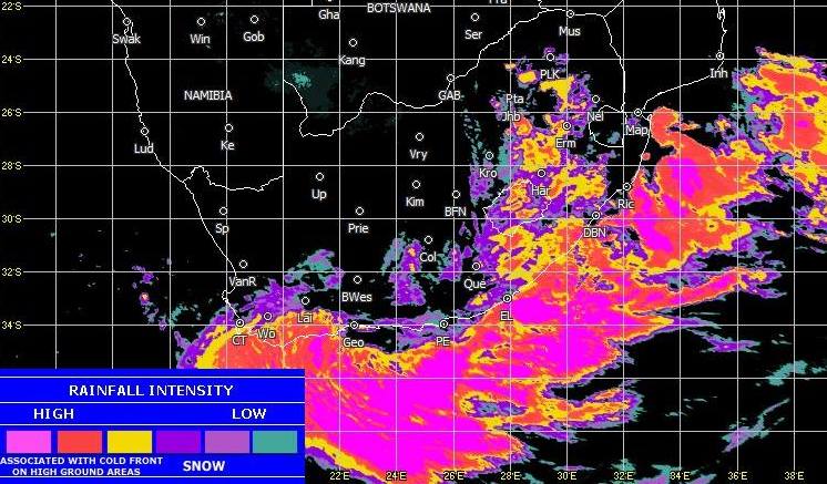
Well, we’re there now, the dams are still full, and while there are a few signs that Spring is on the way, Winter is going to have one (last?) blast at us this weekend, but weirdly, in a Summery kind of way.

There’s a cut-off low expected from tomorrow through until Monday. More often seen in warmer months (which this is not), cut-off lows are characterised in the Western Cape by gale force South Easterly winds and heaps (and heaps) of rain. Experts will tell you that water is not known for its heaping properties, so if the rain is making heaps, you know that there’s a lot of it.

People in the know have been bouncing around numbers like 100mm and 90kph for the precipitation and the gusting winds. Those are fairly significant numbers at any time, but especially when our local ground is already saturated from a seemingly endless winter and our local trees have been battered very recently.

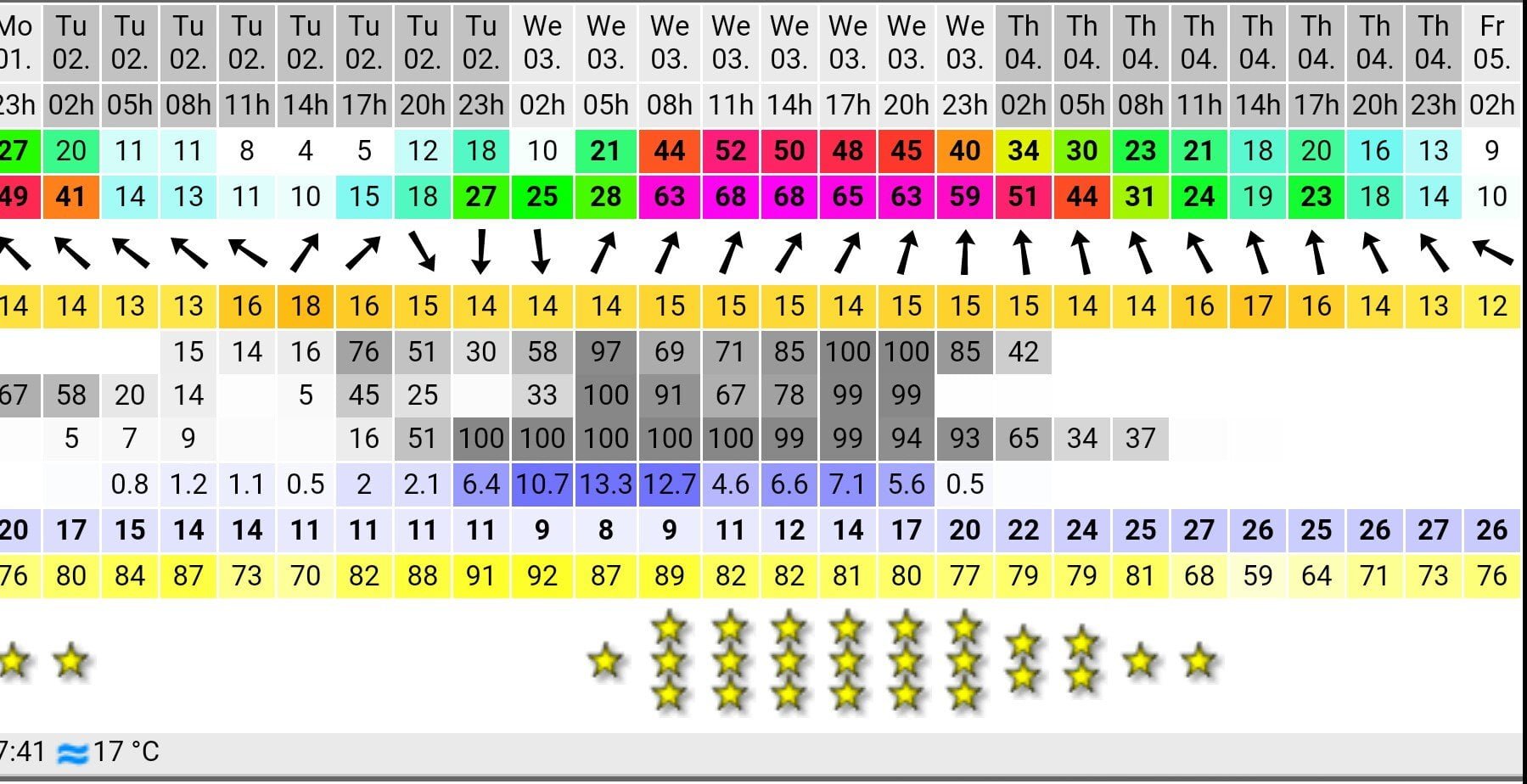
Will that be it then, though? Winter weather-wise? Well, while* there’s nothing nasty in the immediate aftermath of this long weekend’s fun and games:

You’d be hard-pushed to suggest that an average high of 20 would constitute a definite return of Spring to Cape Town.

But at least there’s the sight of a yellow blob each day from Tuesday onwards.

Maybe… just maybe… warmer times are ahead.

* argh! accidental alliteration. awkward.

Wevver

Much rain expected this afternoon and evening for Cape Town and along the Southern Cape coast. This is not unusual: it’s winter. In fact, it’s rather welcome, given the shortages of water we are currently suffering. It would just be nice if it wasn’t all being dumped on us at once.

weather1

And after today, we can expect a further cold front hitting Cape Town on Thursday.

This week’s dam levels were up 4.6% from last week (to 48.1%), but given the amount of rain forecast for the next few days, we can expect an even bigger increase this coming week.

Assuming there’s anything left of the country.

Rain

There was a hint a few years back about a new law in SA which prevented anyone – well, anyone without appropriate qualification, anyway – from publicly commenting on upcoming bad weather. This was obviously a hugely important step in a country where the discussion of upcoming poor meteorological conditions has topped the lists for both most serious and most prevalent crimes for the past decade. Time to end this heinous behaviour.
Here’s Ivo’s view on it.

To be honest, I’ve no clue if that law was ever passed, and thus I’m not willing to stick my neck out and suggest that there may be excessive precipitation headed towards Cape Town on any particular day in the near future. Like, Wednesday, for instance. Simply, I can’t say if that’s going to happen.

Screenshot_2015-06-01-06-41-19~2

It would surely be even more foolhardy of me to do some rudimentary calculations by adding up some apparently random numbers…

rfall

…perhaps including 6.4, 10.7, 13.3, 12.7, 4.6, 6.6, 7.1 and 5.6, and then gasp in amazement and concern that the total of those digits is 67. And were that the number of millimetres of rain to fall in any given 24 hour period, that would be quite a bad thing for wherever it fell on. Especially if some of that place was already at high risk for landslides following large veld fires earlier in the year.

Not that I’m saying that’s what’s going to happen, of course. In Cape Town. Throughout Wednesday.

Because I’d be risking arrest if I told you that.