Brace! Brace!

NUUSFLITS/NEWSFLASH! It’s winter in the Cape and here comes another big cold front to remind us of that fact:

An intense cold front is expected to affect the Western Cape from Thursday night into Friday. The public and small stock farmers are advised that very cold conditions, gale force coastal winds and strong interior winds, heavy rain leading to localised flooding and very rough sea conditions can be expected.

Sounds like fun.

Windguru is predicting swells of up to 9.1m for both Cape Town and Cape Agulhas. Might be time to batten down your beagle, make sure you’ve got enough firewood in and charge up those camera batteries in anticipation. Stormchasing.co.za describes it as:

a powerful cold front… there has never been any doubt that it would be a significant weather event.

And hints at the chance of a light dusting of snow on Table Mountain early on Friday morning.
And I think we can all remember what happened here the last time that happened!

Cape Town storm: emergency numbers

Apparently, it’s going to be a full on nasty afternoon and night weather wise: cold, wet, windy. A typical winter storm as we… er… head towards the end of winter, then.

The City seem more concerned about this one than usual though and have issued several warnings via radio, TV, the interweb and social media. We’re looking at snowfalls, landslides and – mystifyingly, “high fire danger” in the Karoo today.

And yes, probably snow on Table Mountain. Just much rain here right now though.

Anyway, it’s never a bad idea to have some emergency numbers to hand, should there be an emergency and you want to tell someone about it, so here you go:

  • Flooding, blocked drains and service disruptions – 0860 103 089 or SMS 31373
  • Electricity outages/disruptions – 0860 103 089 or SMS 31220.
  • Road Closures, delays on roadways and deviations – 0800 65 64 63
  • Weather Reports – Cape Town Weather Office (021 934 0749/0831), weatherline (083 123 0500), listen to alerts on the radio and television or visit www.weathersa.co.za
  • Emergencies – 107 from a landline or 021 480 7700 from a cellphone

The sooner you phone, the sooner help will arrive.

Bearing in mind that last line, I’ve given each of the numbers a quick call already: it pays to be prepared.

You can also follow the City on twitter or visit their Disaster Management website.
Also on twitter, Cape Town’s Freeway Management Service is very useful.

Is possibility of snow on Table Mountain tomorrow night still on?

Just to keep you inquisitive people who keep asking if we’re still on for a few flakes of the white stuff on Table Mountain tomorrow night,  in the loop – and if you’re in Cape Town today, then you’ll readily believe anything the weather has to throw at us – here’s an update.

Following on from this post which compared the frankly ludicrous claims of mountain-forecast.com – it’s a weather forecast site for mountains, innit? – with those more reasonable efforts of windguru and weathersa, we need to tell you right now that the whole snow on Table Mountain thing IS STILL POSSIBLE.

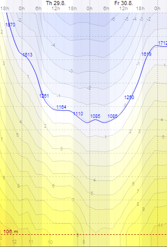
What we’re looking for is temperatures below 2°C at 1000m or below, together with forecasted precipitation. That, plus that will likely equal snow. And here’s the graph that matters:

cold

Yeah. If you thought today was cold, you’d be right, but it’s only going to get colder when tomorrow comes around.

The blue line marks the height above sea level (in metres) at which you’ll experience an air temperature of 0°C. Looking at the contours just below that, you can see that the altitude at which we’ll have 2°C temperatures dips about as low as 800m during Thursday night and Friday morning. Add in cloudy skies and a (current) forecast of about 7-8mm of precipitation and all the ingredients are there.

As things stand right now, your best plan is to wrap up VERY warmly and head for the Cableway early on Friday morning.

Book online to save time and money. Avoid awkward allegations of sexism by making a snowperson. Avoiding awkward allegations of racism will be more difficult, because snow is previously advantaged.