Still pretty, still pricey

Cape Town doesn’t look its best today.

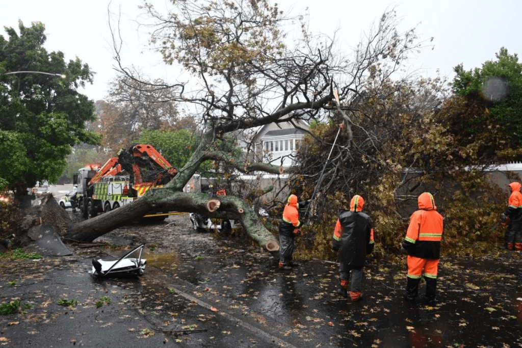
It looks like a scene from a disaster movie, with floods, broken trees, branches and damaged buildings everywhere.

We did get completely battered by yesterday’s storm.

But… give it a couple of weeks (ok, or maybe a month), and all that will be tidied up and forgotten about, and Cape Town will still be the most desirable city on the continent.

Which has its drawbacks:

But still, you’d rather be here than anywhere else.

That was a biggie

Monumental weather today.
Over 100mm of rain, winds gusting to 120kph, just absolute carnage.

Biggest storm this century for the Mother City, allegedly.

I’m finding it hard to disagree.

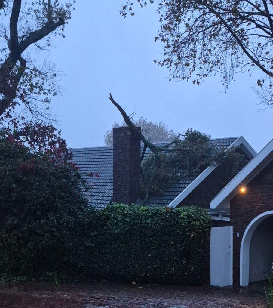
Floods everywhere, trees down – one killing a motorist just around the corner from us – branches all over the place. It’s going to take a while to clear up.
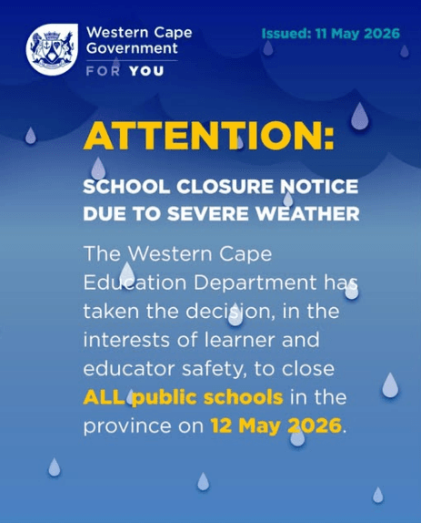
School went ahead for us, but plenty didn’t. And everyone has the day off tomorrow…

…which seems weird, given that today was horrific and dangerous, and tomorrow is just going to be wholly unpleasant. But I doubt that many students will be complaining.

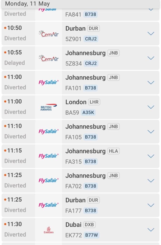
There was a 1½ hour period this morning where nothing could land at Cape Town airport:

Imagine leaving Johannesburg, and then – 4 hours later – ending up in… Johannesburg.

Heartbreakingly awful. Thoughts and prayers.

Locally, there is plenty of damage, with trees down all over the neighbourhood. With the polyphagous shot hole borer beetle epidemic having weakened many of the oak trees around the area, the winds were just too much for a lot of them, and the results are pretty devastating.

If the forecast is correct (and it’s been unerringly accurate today), then we’re just in for about 20mm of rain tomorrow, which is still a lot, unless you’ve had 110mm the previous day, in which case you feel like grabbing your swimsuit and then heading to the beach.

Hopefully, with less wind and less rain, there will be an opportunity to start the clear up: not least for me in our garden. Although, maybe I actually quite like our new rim-flow pool.


INCOMING! (Winter)

Right. That’s it. Summer ended a couple of weeks or a bit more ago, and Autumn has clearly just been bypassed.

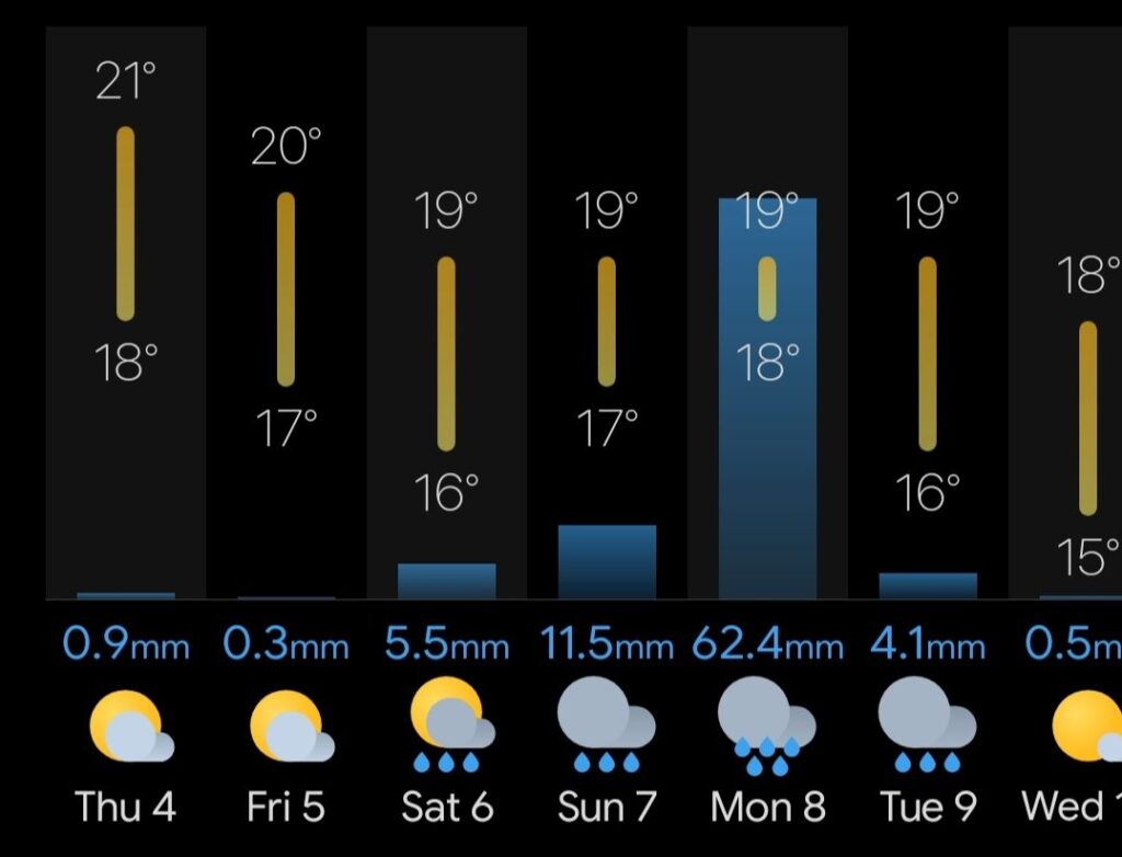
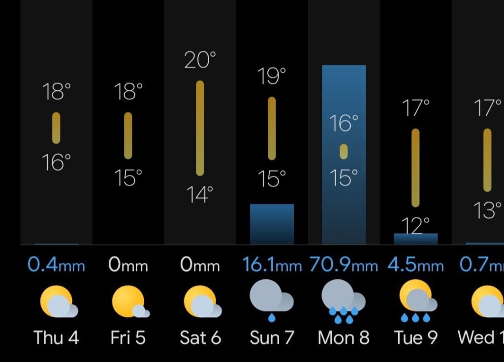
I say this because OMG WTF BBQ have you seen the rain forecast for tomorrow and Monday in the Western Cape?

Bad in Cape Agulhas:

Badder in Cape Town:

I’ve been doing some rudimentary calculations, and that’s a lot of rain.
And this is Black South Easter rain, not a cold front. An overflowing shelf of precipitation, pinned against the Cape coast for 48 hours, not going anywhere.

Might be advisable to check your gutters ahead of the winter, like, now. Today.

And then wrap up warmly, grab some red wine, light the fire, and hunker down.

Here we go again

Gorgeous pre-frontal skies in Cape Town this morning can only mean one thing: a front is coming.

The hint is in the name, see?

And yes, it does look like tomorrow’s weather is going to be pretty ropey, then we’re in for a couple of very chilly days before Sunday, when… well… it’s looking positively biblical.

The weather apps agree on the timing, but are all at odds over the actual amount of rainfall. We’re looking at anything from 10-20mm tomorrow and anything from 22-50mm on Sunday. It’ll be cold and windy as well, just to add injury to injury.
Don’t expect daily highs of anything more than 15°C*.
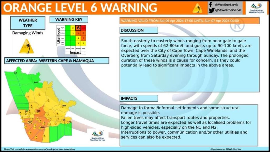
Do expect winds gusting to 85+kph.

All of this will put additional strain on the electricity supply, which doesn’t even do well when everything is peachy, so it’s full-on recipe for disaster stuff. Ugh.

Thus, it would seem likely that tomorrow will be our first fire of the season. For the record, our first fire of last winter was 25th April. This is probably the most predictable weather-related thing that’s ever occurred in Cape Town.

* we’ve been down “15 isn’t cold road” many times before. don’t force me to make you to turn right onto “well 30 isn’t hot avenue”.

The weather: lots going on

I mentioned that there were some rather awful conditions on the higher inland part of my journey on Friday. And then how Saturday was an absolute peach of a day. Today is also stunning: light breeze, near cloudless skies, 26oC. But tomorrow… tomorrow looks like fun. Here’s a weather IR view of the country and surrounds taken about an hour ago:

Top right (purple, round) is Tropical Cyclone Freddy. It’s heading towards Madagascar and has sustained wind speeds of 250kph within. That’s the equivalent of a Category 5 hurricane. Landfall is not going to be pretty.

Then there’s an arc of thunderstorms (orange and red blotches) across the North East of SA. They’re curling down across Botswana and Namibia and might even get down as far as the Western Cape. But they’re likely to be pushed back by that huge cold front (multicoloured swoosh) in the bottom left.
That’s going to hit Cape Town tomorrow and promises to bring “high intensity” rain and strong winds to the Western Cape.

It’s not like we don’t need the rain. We just don’t need it all in one go.

My apps are suggesting the wind turning to the NW late this evening and then increasing in strength throughout the morning. The rain seems to arrive just before dawn, with the heaviest stuff mid to late morning, correlating with the wind which could gust to 92kph.

According to sources, it “demands absolute attention”, so while it’s not a Freddy in any way, shape or form, it’s still probably best not to underestimate it.

Stay safe.